Severe storms with intense tornadoes expected to continue in Central US through Monday
Severe Storms with Intense Tornadoes Expected to Continue in Central US Through Monday
Severe storms with intense tornadoes expected – The central United States is preparing for a major weather event as a series of intense thunderstorms begins to develop across the Plains and Midwest. This pattern is anticipated to persist through Tuesday, posing significant risks of powerful tornadoes, including EF3 or stronger, along with damaging hail, strong winds, and heavy rainfall. May has historically been a time of heightened severe weather activity in this region, and this storm system could match that trend. The transition from a relatively calm beginning to this active period is attributed to a shift in the jet stream, which has previously limited widespread severe storms.
Regional Tornado Threats and Watch Alerts
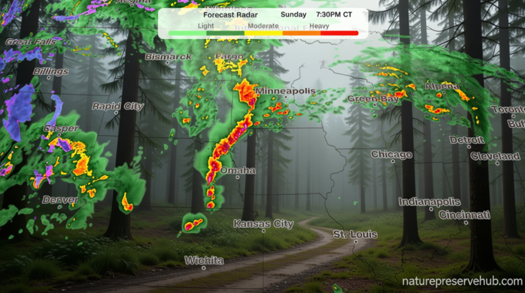
This week’s weather forecast highlights a sharp increase in tornado risk, particularly over Sunday and Monday. The National Weather Service has confirmed at least one tornado in central Nebraska, underscoring the urgency of the situation. Tornado watches have been issued across a vast portion of the central U.S., encompassing three million people. The most severe threat spans eastern Nebraska, southeastern South Dakota, northern Kansas, and western Iowa, including cities such as Omaha, Lincoln, and Sioux City.
“A tornado was confirmed north of Grand Island, Nebraska, in the central part of the state,” stated the National Weather Service.
By this evening, the storm system is expected to organize into a line, increasing the likelihood of winds exceeding 80 mph. These conditions could lead to widespread damage, especially in areas where the storms linger into the early morning hours. The morning’s storm activity may also influence afternoon conditions, as lingering cloud cover could reduce the energy available for new thunderstorms.
Monday’s Widespread Storm Activity
As the week progresses, the potential for severe thunderstorms expands on Monday. A major surge in jet stream energy will interact with abundant moisture in the Plains, creating a widespread outbreak. Supercells, which often form in the afternoon, are likely to generate tornadoes ranging from EF2 to EF3 in strength, alongside large hail. The primary tornado risk is concentrated in central and eastern Kansas, extending into southeastern Nebraska and northwestern Missouri.
By late evening, the focus will shift to damaging winds, though some tornadoes may still develop into the overnight hours. The exact timing and intensity of these storms remain uncertain, with factors such as morning cloud cover playing a critical role in determining the afternoon’s threat level. Areas where storms from Sunday night persist into the morning may experience diminished energy, affecting the strength of subsequent storms.
Tuesday’s Transition and Fire Risk
Tuesday brings a gradual change in the storm pattern, with ongoing thunderstorms expected from northern Texas to Michigan. While the threat of strong to severe storms will intensify through the afternoon, the dominant trigger will shift to a cold front. This transition will reduce the likelihood of tornadoes, with wind and hail becoming the main concerns.
Simultaneously, the same weather system responsible for tornado activity will contribute to dry and windy conditions in the Southern High Plains. A level 3, extremely critical fire threat is active in this region from Sunday to Monday, covering areas from southwestern Kansas to the Texas Panhandle and northeastern New Mexico. A level 2, critical threat extends to much of New Mexico, highlighting the severity of the risk.
The National Weather Service notes that sustained winds of 25 to 30 mph, gusts up to 50 mph, and relative humidity below 10% will combine with dry fuels to accelerate the spread of any fires that ignite. These conditions create a perfect storm for wildfires, particularly in areas with limited vegetation moisture.
The overall impact of this weather system will be felt across multiple regions. While the Midwest braces for tornadoes, the Southwest faces a heightened risk of wildfires. This dual threat underscores the complexity of weather patterns in May, which often challenge preparedness efforts. The transition from one type of hazard to another—tornadoes to wind and hail, and then to fire risk—illustrates the dynamic nature of atmospheric conditions during this time of year.
Residents are advised to stay alert and monitor updates from the National Weather Service. The combination of intense storms and fire risk requires a multifaceted approach to safety, with communities in the Central U.S. and Southwest preparing for potential disruptions. The week’s weather forecast serves as a reminder of the power and unpredictability of May’s storms, which can rapidly shift from one danger to another.
As the storm system evolves, the Central Plains and Midwest will continue to experience high levels of activity. The potential for EF3 tornadoes, coupled with the risk of wildfires, means that the region must remain vigilant throughout the week. This event is shaping up to be one of the most significant in May, with implications for both safety and infrastructure across the affected areas.
